Software
HYDROMAP™
download PDFHydrodynamic Modeling System
HYDROMAP generates current and water level predictions for
any coastal waters around the world.
Applications for HYDROMAP
- Currents for complex coastline geometry river-estuarine system and open geometry of the coastal shelf simultaneously
- Current data files for other RPS ASA models
- Hindcast/forecast current simulations
- Drills and education
Features
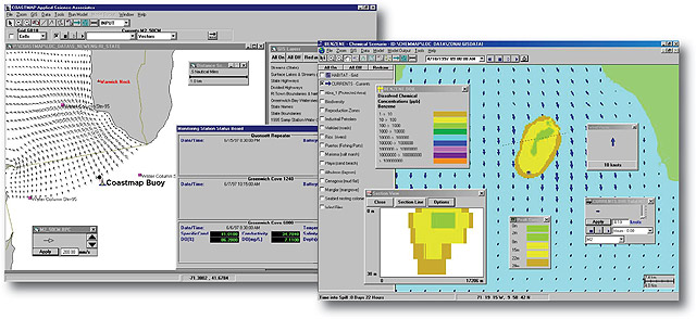
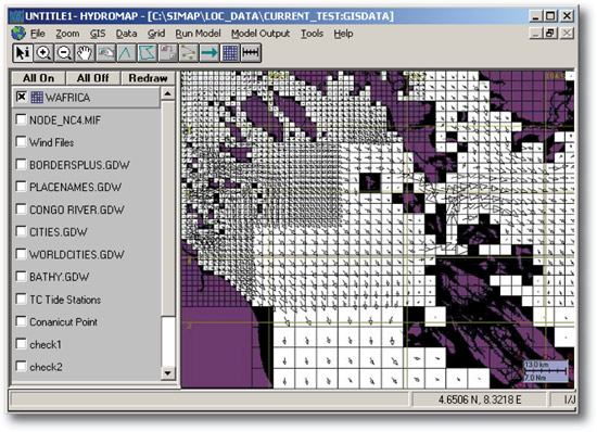
- Contains RPS ASA’s own GIS
- Easy access and input of required data for current simulations
- Gridding tools allow the user to create a rectangular grid system and easily select locales within that grid structure for finer grid resolutions
- Output of current data automatically linked to other RPS ASA models
- Variety of hydrodynamic file formats
- Easily interpreted visual displays of animated currents
HYDROMAP Highlights
- Integrated GIS
- Rapid implementation and interoperability
- Windows based
- Handles complex coastline geometry via novel modeling techniques
* More advanced than standard finite difference nesting structure by enabling several levels of grid
size to be constructed and executed simultaneously.
HYDROMAP’s advanced gridding approach allows large areas of widely differing spatial scales to be addressed within one consistent model application.
Stepwise-Continuous-Variable-Rectangular grid (SCVR):
- Advanced finite difference nesting structure
- Enables several levels of grid size to be constructed and executed simultaneously
- Stepwise-Continuous - boundaries between successively larger and smaller grid sizes are managed in a consistent integer stepped manner
- Variable -grid-cell sizes are variable over the grid domain
Hydrodynamic model:
- Continuous vertical profiles to represent velocity, temperature, and salinity
- Solves the equations of motion for the water movement in a single simulation
Data required to grid and force simulations:
- Coastline definition to define the land-water boundary
- Bathymetry contours or soundings to defi ne the depth of water cells in the grid
- Tidal elevation constituent harmonic definitions (elevation and phase)
- Optional long term wind stress forcing
- Publicly available sources for required data are either packaged with HYDROMAP or can be easily accessed through HYDROMAP tools